Skip to Main Content
|
|
|
Toggle navigation
Ask a Librarian
View Hours
Support the Library
My Accounts
Search
Catalogs
Library Catalog
UBorrow
BorrowDirect
WorldCat
Other Catalogs
Other Search Tools
Articles Plus
Database Finder
EJournals
Website Search
Borrow
& Request
Borrowing
Borrowing & Renewing
Due Dates & Loan Periods
Fines & Lost Items
Course Reserves
My Accounts
Requesting
Request Articles & Chapters
Request Books & Other Media
Suggest a Purchase
Research
& Teaching
Research Help & Tools
Ask a Librarian
Subject Specialists
Citation Management
Help Guides
Subject Guides
Teaching Support
Course Reserves
Research Instruction for Courses
Scholarly Communication & Publishing
Dissertation Office
Digital Scholarship
Copyright Info
Collections
& Exhibits
Collections
Notable Collections
Digital Collections
Collecting Areas by Subject
Other Local Collections
Exhibits
All Exhibits
Web Exhibits
Research Centers
East Asian Collection
Maps Collection
Southern Asia Collection
Special Collections
Spaces
& Services
Using Our Spaces
Visiting the Library
Library Hours
Book a Room
Places to Study
Copy, Print, Scan
TECHB@R
Libraries
Our Locations
Crerar
D'Angelo Law
Eckhart
Mansueto
Regenstein
Special Collections
SSA
About
About the Library
Mission & Strategic Plan
Facts
Departments & Staff
Employment
Support the Library
Library Surveys & Reports
Library Policies
Conferences
Library Boards & Committees
News & Events
News
Workshops & Events
Libra (newsletter)
Social Media Directory
Collections & Exhibits
>
Collections
>
Mapping Chicagoland
> Results with subjects: Housing
Results with subjects: Housing
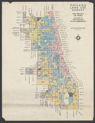
Dwelling units, 1934.
Local ID(s):
maps-0144
Language(s):
English
Spatial(s):
7013596
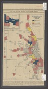
New single family dwellings erected in Chicago area in last five years (1934-1938).
Local ID(s):
maps-0146
Language(s):
English
Spatial(s):
7013596
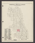
Social Science Research Committee maps of community areas of Chicago.
Local ID(s):
maps-0147
Language(s):
English
Spatial(s):
7013596
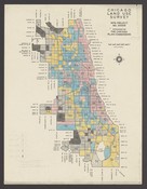
Percentage of dwelling units occupied by owner by census tracts in 1930.
Local ID(s):
maps-0141
Language(s):
English
Spatial(s):
7013596
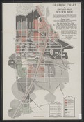
Graphic chart of Chicago's great South Side.
Local ID(s):
maps-0140
Language(s):
English
Spatial(s):
Illinois -- Chicago Region
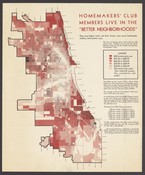
Homemakers' Club members live in the "better neighborhoods" :they pay higher rents, eat finer foods, wear more fashionable clothes, drive better cars.
Local ID(s):
maps-0145
Language(s):
English
Spatial(s):
7013596
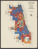
Median rental, 1930.
Local ID(s):
maps-0142
Language(s):
English
Spatial(s):
7013596
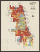
Median rental by census tracts in 1934.
Local ID(s):
maps-0143
Language(s):
English
Spatial(s):
7013596
Search & Browse
Browse Collection by
Subject
Decade
Subject Specialist
Cecilia Smith
Director of Digital Scholarship
ceciliasmith@uchicago.edu
1-773-702-8761