Skip to Main Content
|
|
|
Toggle navigation
Ask a Librarian
View Hours
Support the Library
My Accounts
Search
Catalogs
Library Catalog
UBorrow
BorrowDirect
WorldCat
Other Catalogs
Other Search Tools
Articles Plus
Database Finder
EJournals
Website Search
Borrow
& Request
Borrowing
Borrowing & Renewing
Due Dates & Loan Periods
Fines & Lost Items
Course Reserves
My Accounts
Requesting
Request Articles & Chapters
Request Books & Other Media
Suggest a Purchase
Research
& Teaching
Research Help & Tools
Ask a Librarian
Subject Specialists
Citation Management
Help Guides
Subject Guides
Teaching Support
Course Reserves
Research Instruction for Courses
Scholarly Communication & Publishing
Dissertation Office
Digital Scholarship
Copyright Info
Collections
& Exhibits
Collections
Notable Collections
Digital Collections
Collecting Areas by Subject
Other Local Collections
Exhibits
All Exhibits
Web Exhibits
Research Centers
East Asian Collection
Maps Collection
Southern Asia Collection
Special Collections
Spaces
& Services
Using Our Spaces
Visiting the Library
Library Hours
Book a Room
Places to Study
Copy, Print, Scan
TECHB@R
Libraries
Our Locations
Crerar
D'Angelo Law
Eckhart
Mansueto
Regenstein
Special Collections
SSA
About
About the Library
Mission & Strategic Plan
Facts
Departments & Staff
Employment
Support the Library
Library Surveys & Reports
Library Policies
Conferences
Library Boards & Committees
News & Events
News
Workshops & Events
Libra (newsletter)
Social Media Directory
Collections & Exhibits
>
Collections
>
Mapping Chicagoland
> Results with decades: 1900s
Results with decades: 1900s
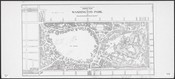
General plan of Washington Park.
Local ID(s):
maps-0369
Language(s):
English
Spatial(s):
1103114
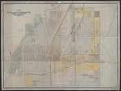
Map of Chicago Heights, Cook County, Illinois, 1906 /
Local ID(s):
maps-0376
Language(s):
English
Spatial(s):
2027150
[Plat map of part of Near North Side, Chicago].
Local ID(s):
maps-0356
Language(s):
English
Spatial(s):
7013596 7022156
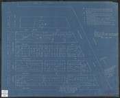
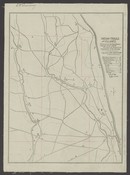
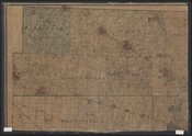
Central Manufacturing District.
Local ID(s):
maps-0315
Language(s):
English
Spatial(s):
7013596
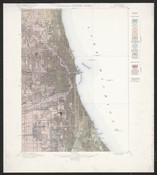
Economic geology sheet :[Chicago and vicinity].
Local ID(s):
maps-0085
Language(s):
English
Spatial(s):
Illinois -- Chicago Region
Indian trails and villages :centered to the north branch, Chicago River, 1804, as shown by weapons and implements of the stone age.
Local ID(s):
maps-0095
Language(s):
English
Spatial(s):
Illinois -- Chicago Region
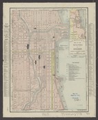
Rand McNally & Co.'s map of the central portion of Chicago, showing railroads, depots, and street transportation lines.
Local ID(s):
maps-0068
Language(s):
English
Spatial(s):
7013596
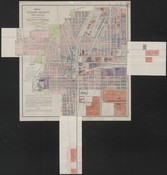
Rand, McNally and Co.'s street number guide map of the principal part of Chicago ; Rand, McNally & Co.'s street guide map of Chicago and suburbs showing the city limits.
Local ID(s):
maps-0013
Language(s):
English
Spatial(s):
7013596
Map of Chicago Heights, Cook County, Ill. /
Local ID(s):
maps-0377
Language(s):
English
Spatial(s):
2027150
Mitchell's real estate map of Cook and Du Page Counties, and part of Will County, Illinois, and northwest portion of Lake County, Indiana.
Local ID(s):
maps-0032
Language(s):
English
Spatial(s):
Illinois -- Chicago Region
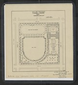
Cornell Square.
Local ID(s):
maps-0358
Language(s):
English
Spatial(s):
7013596 Illinois -- New City (Chicago)
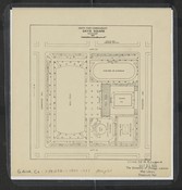
Davis Square.
Local ID(s):
maps-0359
Language(s):
English
Spatial(s):
7013596 Illinois -- New City (Chicago)
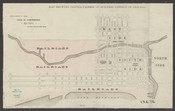
Map showing contractedness of business district of Chicago.
Local ID(s):
maps-0067
Language(s):
English
Spatial(s):
7013596 7015700
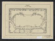
Ogden Park.
Local ID(s):
maps-0371
Language(s):
English
Spatial(s):
7013596
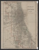
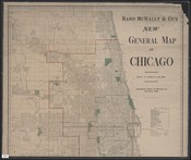
Rand McNally & Co.'s new general map of Chicago.
Local ID(s):
maps-0014
Language(s):
English
Spatial(s):
7013596
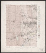
Areal geology sheet :[Chicago and vicinity].
Local ID(s):
maps-0084
Language(s):
English
Spatial(s):
Illinois -- Chicago Region
Search & Browse
Browse Collection by
Subject
Decade
Subject Specialist
Cecilia Smith
Director of Digital Scholarship
ceciliasmith@uchicago.edu
1-773-702-8761