Skip to Main Content
|
|
|
Toggle navigation
Ask a Librarian
View Hours
Support the Library
My Accounts
Search
Catalogs
Library Catalog
UBorrow
BorrowDirect
WorldCat
Other Catalogs
Other Search Tools
Articles Plus
Database Finder
EJournals
Website Search
Borrow
& Request
Borrowing
Borrowing & Renewing
Due Dates & Loan Periods
Fines & Lost Items
Course Reserves
My Accounts
Requesting
Request Articles & Chapters
Request Books & Other Media
Suggest a Purchase
Research
& Teaching
Research Help & Tools
Ask a Librarian
Subject Specialists
Citation Management
Help Guides
Subject Guides
Teaching Support
Course Reserves
Research Instruction for Courses
Scholarly Communication & Publishing
Dissertation Office
Digital Scholarship
Copyright Info
Collections
& Exhibits
Collections
Notable Collections
Digital Collections
Collecting Areas by Subject
Other Local Collections
Exhibits
All Exhibits
Web Exhibits
Research Centers
East Asian Collection
Maps Collection
Southern Asia Collection
Special Collections
Spaces
& Services
Using Our Spaces
Visiting the Library
Library Hours
Book a Room
Places to Study
Copy, Print, Scan
TECHB@R
Libraries
Our Locations
Crerar
D'Angelo Law
Eckhart
Mansueto
Regenstein
Special Collections
SSA
About
About the Library
Mission & Strategic Plan
Facts
Departments & Staff
Employment
Support the Library
Library Surveys & Reports
Library Policies
Conferences
Library Boards & Committees
News & Events
News
Workshops & Events
Libra (newsletter)
Social Media Directory
Collections & Exhibits
>
Collections
>
Mapping Chicagoland
> Results with decades: 1890s
Results with decades: 1890s
Columbian Exposition :a bird's-eye view of the buildings and grounds as they will appear in 1893 /
Local ID(s):
maps-0374
Language(s):
English
Spatial(s):
(:unav)
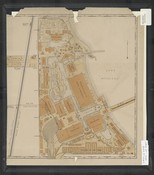
[Fire insurance maps of part of Kenwood, Chicago, Illinois].
Local ID(s):
maps-0347
Language(s):
English
Spatial(s):
7013596 8722163
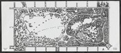
[Map of Washington Park :Chicago, Ill.].
Local ID(s):
maps-0368
Language(s):
English
Spatial(s):
1103114
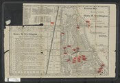
Standard map showing exhibits of Henry R. Worthington at the World's Columbian Exposition at Chicago, 1893.
Local ID(s):
maps-0375
Language(s):
English
Spatial(s):
(:unav)
Rand McNally and Co.'s new map of Chicago and suburbs showing the location of the World's Columbian Exposition, streets, parks, boulevards, railroads, street car lines, etc.
Local ID(s):
maps-0281
Language(s):
English
Spatial(s):
7013596
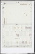
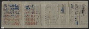
Wage map no. 1[-4], Polk St. to Twelfth ... Chicago.
Local ID(s):
maps-0357
Language(s):
English
Spatial(s):
7013596 7015700 Illinois -- Chicago -- Near West Side
[Columbian Exposition, 1893].
Local ID(s):
maps-0373
Language(s):
Italian
Spatial(s):
(:unav)
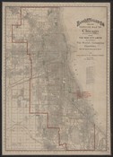
Rand McNally and Co.'s new and concise map of Chicago showing the new city limits and location of the World's Columbian Exposition, streets, parks, boulevards, railroads, street car lines, etc.
Local ID(s):
maps-0282
Language(s):
English
Spatial(s):
7013596
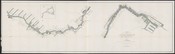
Map & profile of the proposed routes for a waterway between Lake Michigan & Mississippi River, surveyed in accordance with act of Congress, August 11, 1888, under the direction of Captain W.L. Marshall, Corps of Engineers, U.S.A. by L.L. Wheeler, U.S. Assistant Engineer, 1888-1889.
Local ID(s):
maps-0250
Language(s):
English
Spatial(s):
2236134 7013596
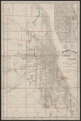
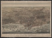
The city of Chicago.
Local ID(s):
maps-0078
Language(s):
English
Spatial(s):
7013596
Search & Browse
Browse Collection by
Subject
Decade
Subject Specialist
Cecilia Smith
Director of Digital Scholarship
ceciliasmith@uchicago.edu
1-773-702-8761